


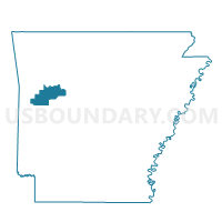
Driggs Voting District, Logan County, Arkansas
About
Outline

Summary
| Unique Area Identifier | 527139 |
| Name | Driggs Voting District |
| County | Logan County |
| State | Arkansas |
| Area (square miles) | 23.76 |
| Land Area (square miles) | 23.71 |
| Water Area (square miles) | 0.05 |
| % of Land Area | 99.79 |
| % of Water Area | 0.21 |
| Latitude of the Internal Point | 35.22812470 |
| Longtitude of the Internal Point | -93.78953540 |
Maps


Graphs
Select a template below for downloading or customizing gragh for Driggs Voting District, Logan County, Arkansas


Neighbors
Neighoring Voting District (by Name) Neighboring Voting District on the Map
- Mountain Voting District, Logan County, AR
- Ratcliff Rural Voting District, Logan County, AR
- Reveille Rural Voting District, Logan County, AR
- Short Mountain Ward 4, Logan County, AR
- Washburn Voting District, Logan County, AR
Top 10 Neighboring County Subdivision (by Population) Neighboring County Subdivision on the Map
- Short Mountain township, Logan County, AR (5,011)
- Reveilee township, Logan County, AR (1,462)
- Six Mile township, Logan County, AR (1,042)
- Washburn township, Logan County, AR (821)
- Driggs township, Logan County, AR (517)
- Mountain township, Logan County, AR (131)
Top 10 Neighboring Unified School District (by Population) Neighboring Unified School District on the Map
- Paris School District, AR (7,279)
- County Line School District, AR (3,436)
- Magazine Schools, AR (2,682)